Saturday, 28 January 2017

As mentioned in my last post, the coastal scenery on the West Coast of NZ, from Westport down to Punakaiki (Pancake Rocks), was absolutely spectacular. The Rocks themselves were also stunning and very unusual. It's a very popular tourist stop, just off the highway. From this picture you can see why they're called Pancake Rocks, they are composed of layered limestone reminiscent of thin pancakes.


In addition to the layered limestone, the area is heavily eroded and there are many caverns and blowholes, where, at high tide, the water explodes to the surface, like a geyser.


The Rocks were also home to nesting terns and there were many of them all along the topmost ledges.


 photo arrow.pngCONTINUE READING

Wednesday, 25 January 2017

After leaving the Nelson area, we headed over to the northwest tip of the South Island to explore the top end of the wild West Coast. From Karamea at the top, down to Greymouth. The Coast Road between Westport and Punakaiki (Pancake Rocks) has to be the most scenic coastline we've ever seen, anywhere and that's saying a lot. The road is very narrow and there aren't any places to pull over, so, not many pictures, but, it was spectacular: lush green forest, cliffs, jagged rocks and a wild sea. Along the way, we stopped at Cape Foulwind (love that name) to view the seal colony there. I know I've published a bunch of seal pictures recently, but, really, how could I resist sharing this one.


At the end of road, just north of Karamea, is the start of the Heaphy Track, a five day Great Walk that goes through Kahurangi National Park. We had no plans to do the Heaphy Track, but, there were a couple of short walks at its terminus that sounded interesting, especially the Nikau Palm Forest Walk.

A suspension bridge led into the forest.


A forest of palm trees is just as lush and green as you'd expect.


Occasionally, a glimpse through the forest showed pohutukawa trees blooming red on the hillsides.


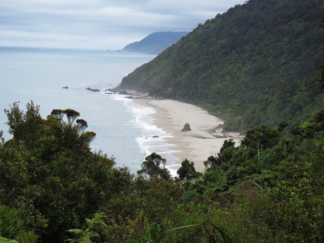
The walk led to a scenic lookout over the first beach on the Heaphy Track.


The way back was just as pretty as the way in.


As usual, there was also lots of birdlife to enjoy. These are cormorants, known in NZ as 'shags'.


 photo arrow.pngCONTINUE READING

Friday, 20 January 2017

One of our three chosen Great Walks that we had wanted to do, the Abel Tasman Coast Track, in Abel Tasman National Park, was fully booked. It was an 'easy' track, level, sandy and involving many beaches. We were disappointed when we couldn't get on it. Like the Milford Track, it probably needs to be booked a year in advance. We've wanted to try sea kayaking for a while now and there are nine companies offering various trips and tours through the park. Realizing that these commercial operations would have already pre-booked their campsites, we would therefore still be able to visit the park if we signed up for one of their tours. So, we did. We were able to get on a three day tour with the Sea Kayak Company (http://www.seakayaknz.co.nz/), out of Motueka, during the first week of January. It was a small group, two Germans, a US family of three and our guide, Ethan. Just four kayaks in all.


Although the trip wasn't without weather challenges, it was a great choice of company. All food (delicious and lots of it), transport and equipment was provided. First day, we left from Marahou beach, via water taxi, to the northernmost part of our itinerary from where we would paddle back to Marahou over the three days. Our kayaks had already been taken to the start point earlier in the day and we just had to carry all our personal gear and the group's food aboard the taxi. The day was overcast and threatened rain. There was a slight wind in our favour which was good for the first time out. It took a while to get into our stride in the kayak, it's very different from canoeing and seemed very unnatural at first. Due to our past canoe and sail experience, though, we felt comfortable out on the water with the slight swell and waves. We arrived at the first campsite and snagged a prime site for our tent.


There was a nice beach, a forest pool and interesting sea caves to explore here at Onetahuti Bay.


Ethan, our guide, did the cooking and for the first night's "pudding" (dessert), presented us with this great Pavlova, a unique NZ dessert consisting of meringue topped with fresh cream, berries and usually kiwi fruit. This version maybe wouldn't win a beauty contest, having been slightly squashed in the kayak, but, it tasted absolutely delicious and we all enjoyed it very much.


We were entertained in camp by a group of Pukeko. Check out the big feet with extra long toes, which, because they need to be lifted so high for each step, makes them look like they are walking with galoshes on.


We also had a bunch of cheeky wekas to enjoy. These are flightless birds, but, are known to have a mischievous nature and will walk off with campers' possessions if you're not careful.


It started raining overnight and it absolutely poured rain for all of Day Two. The rain dampened the sea, so, the kayaking was fairly easy, but, we were all miserable by early afternoon and couldn't wait to stop for the day. We visited some beautiful spots along the way, tiny tidal estuaries that you could only reach via kayak and it would have been magical on a good weather day. Unfortunately, we didn't  want to linger and in the end, just made a beeline for our next stopping point, Anchorage Bay.


The rain stopped about five p.m., we made a good campfire and once dry, our spirits lifted and we enjoyed a good dinner of vegetable curry. Dessert tonight was a huge chocolate brownie each, smothered in chocolate sauce, whipped cream and strawberries!

Day Three was to be a long paddle back to Marahou. As soon as we turned the first corner we knew we could be in trouble. The wind was 'on the nose' (as it always seems to be when we're sailing also) and the sea was starting to whip up. It was hard going, but, we made it to the last headland where, once we turned, we knew we were done for. The wind was coming at us, steadily, around 25-30 knots. That's no wind for a kayak. We couldn't make progress against it and it started blowing us out to sea and we had to retreat. We rode downwind for a while and decided to try once more. Still no progress was possible. Our instructor radioed in for a water taxi pickup, none was available until four p.m. So, we rode back downwind and tucked into a beautiful, sheltered bay where we put up a tarp, enjoyed a huge picnic lunch and laid on the beach, in the hot sun, until it was time to head back to Anchorage Bay, where we'd left from that morning. The last half-mile into the beach was a struggle, but, the taxi trip back to Marahou was uneventful. We learned later that another group had experienced a capsize and that all the kayakers that were out had needed to get off the water.

So, canoeing, or, kayaking? We like river/estuary travel by canoe and kayak, the next bend is always unknown and intriguing, but, found that kayaking on a large, open sea is a little boring and potentially not much fun when the wind and sea kick up. All in all, a good learning experience and now we know what sea kayaking is like.

Once back to our car, we spotted these horseback riders on one of the many beautiful beaches in the area.


 photo arrow.pngCONTINUE READING

Wednesday, 18 January 2017

In the Nelson area, there are three National Parks: Abel Tasman, known for its golden sand beaches, sea kayak and Great Walk opportunities; Kahurangi, known for its Heaphy Track Great Walk and Nelson Lakes, known for Lakes Rotoiti and Rotoroa, but, also, for its glaciated valleys and excellent tramping. We headed to Nelson Lakes Park for New Year. We had a couple of days to fill before we needed to head over to Abel Tasman for our sea kayaking trip (more on that later) and hoped we could find a day hike to do. When we read in Lonely Planet that the St. Arnaud Range Track, in Nelson Lakes National Park, was rated one of the Top Five Wildlife Encounters (for Birdlife) in NZ, well, it was the obvious choice! The track started at Kerr Bay on Lake Rotoiti


It was an 11km walk, suggested as five hours. It took us a while longer as it was a continuous up, along many switchbacks, through the beech forest, about a 600m climb above Lake Rotoiti to 1650m. Once above the treeline it became quite steep and there was loose rock, meaning we took our time and were careful. The views from the top were absolutely spectacular and worth the effort.


Rain had been threatening all day, but, luckily had held off until we reached the summit. It started spitting at the top, so, after a very short stop, we headed down as quickly as we could.

Along the way we were rewarded with some sightings of birdlife. We encountered a rare kaka, a very large, wild, parrot. This isn't a good picture, but, maybe will give you some idea of its magnificence.


At the other end of the scale, here is a delightful little tomtit. These are supposed to be elusive to see up close, but, this one seemed very curious and actually kept coming to us, instead of away. What a charmer.


The dull, overcast day made the forest somewhat gloomy, although it was brightened, in places, by Alpine-like plants in fresh spring bloom.


This area of the park is part of the Rotoiti Nature Recovery Project. This project is trying to eradicate  non-native pests, like possums, stoats, ferrets, weasels, rats, mice and wasps from parcels of land that are fairly isolated and enclosed by natural obstacles. There is intensive trapping and use of poisons to achieve this, which is controversial, but, the numbers of native species have definitely recovered, to some extent, in this area at least. We were treated to an incredible example of the numbers of recovered birdlife here when we experienced the most incredible 'dawn chorus' we've ever heard. The forest surrounding the campground came alive around 5 a.m. and shut off, like somebody turned a switch, at dawn. While it was playing, there was a single bird that sounded like it was singing notes on a scale, one note rising in sequence after another, with thousands of others sweetly singing background for it. It was amazing and very lovely, beats an alarm clock any day.

 photo arrow.pngCONTINUE READING

Friday, 13 January 2017

Our first destination in the South Island of NZ was Nelson. Established in 1841, it is the second-oldest settled city in New Zealand, the oldest in the South Island and was proclaimed a city by royal charter in 1858. There are around 50,000 people these days. We were pleasantly surprised by how welcoming it was and it soon went to the top of the list as our favourite NZ town to date. We spent quite a bit of time there, over the Christmas period, visiting friends, getting our mail and doing various other admin tasks. The town is well situated, almost at the geographic centre of NZ and due to its location and temperate oceanic climate is known as 'Sunny Nelson'. On one of those beautiful sunny days we hiked up to the 'Centre of NZ' monument where the town was spread out below us. In the distance the golden coastline of Abel Tasman National Park could be seen, one of three National Parks in the area.


The central business district was fully occupied, clean, inviting and the many sidewalk cafes and bars were all packed with people. We soon found a couple of favourite haunts: the Swedish Bakery, where we quickly became addicted to their date and orange scones and Chocdee, a reasonably-priced (for NZ) Thai restaurant where we enjoyed a couple of excellent dinners out, a real treat. The Saturday Farmer's Market was also amazing, with locally grown fresh fruit on offer. We're enjoying spring treats like cherries, strawberries and asparagus for the second time this year!

The streetscape is interesting with many heritage buildings.


The houses were beautifully kept and many were festooned with cascades of spring blossoms.


One thing we really like about NZ is that most of the houses are very modest, by North American standards, but, the scale seems more appropriate if you're searching for a simpler life. We find the many examples of Victorian and Edwardian Cottage-style very appealing.


On Christmas Eve, we attended the candlelight carol sing on the cathedral steps in the centre of town. The cathedral is Art Deco-styled and somehow, to me, just doesn't have the same architectural appeal as a traditional, European, medieval Gothic cathedral, but, I suppose some people like it and it certainly takes centre stage and dominates the town. It seemed crazy to be singing Jingle Bells and the like on a beautiful, warm evening with palm trees and blossoms all round.There were a few special NZ carols as well that were more apropos for a Southern Hemisphere Christmas celebration.


 photo arrow.pngCONTINUE READING

Tuesday, 10 January 2017

As our final stop on the North Island, before taking the ferry to the South Island, we spent an enjoyable couple of days at Cape Palliser, the southeast point of the North Island. It was obligatory to climb to the lighthouse, I think there were, "puff-puff", 250 steps, more or less.


The weather has been alternating between absolutely miserable one day and glorious the next. Today, it was a glorious day. The sea, the fresh wind, the flowers, the blue sky, the clear view right across Cook Strait to the South Island and the seals are a lasting memory.


Evidence of not so glorious weather could be seen in this unfortunate cliffhanger.


We spent a long time watching the seals. They were all over the rocks, sunning themselves.


This family seemed to be having a domestic.


These are known as New Zealand fur seals, but, technically, I think they're sea lions. I found this definition of the difference, the ear flaps and walking on their front flippers both say 'sea lion'.

"Seals and sea lions are marine mammals called 'pinnipeds' that differ in physical characteristics and adaptations. Sea lions are brown, bark loudly, "walk" on land using their large flippers and have visible ear flaps. Seals have small flippers, wriggle on their bellies on land, and lack visible ear flaps."


 photo arrow.pngCONTINUE READING

Sunday, 8 January 2017

The Lake Taupo/Rotorua area of the North Island is where the geothermal tourist attractions are located. Taupo, the town, is very modern, glossy and expensive-looking. Rotorua is older, but, has history and charm to its credit. The museum building and its surrounding parkland are stunning.


The hotels have charm.


There is lots of steaming geothermal activity in town and some people are lucky enough to have one of these in their backyard. Handy for boiling eggs, I suppose.


In one corner of town, on the waterfront, there is a historic Maori village with the most beautiful marae (meeting house) we've seen yet.


The carving was truly amazing.


There were other Maori-themed features scattered around town.


The carving on this war canoe was incredible.


 photo arrow.pngCONTINUE READING