Tuesday 26 July 2016

During our recent fourteen day canoe trip on the Yukon River, from Whitehorse to Dawson City, Fort Selkirk was about the halfway point and a logical place to stop for a rest day.


It was a worthwhile stop as it took us almost half a day alone to explore the history of this ghost town. A Hudson Bay Trading Post was first established here in 1848. In 1852 it was looted and destroyed by the Tlingits and wasn't rebuilt until about forty years later. From then until the mid-1950's it was a thriving community. Many of the buildings have been restored and the Fort Selkirk Historic Site is owned and managed jointly by the Selkirk First Nation and the Yukon Government's Department of Tourism and Culture. There is no road access. It is in a stunning location, at the confluence of the Pelly and Yukon Rivers. A formidable basalt wall is across from the settlement, which sits high above the river.


Fort Selkirk was also important during the Gold Rush Years, primarily due to the creation of the Yukon Field Force which were in formation between 1898-1900. Canada was a young country at the time, only thirty-one years old in 1898. It was interesting to note that one quarter of the country's entire military, 203 men, was sent to Fort Selkirk in 1898 as the Yukon Field Force. There is a graveyard and memorial to them in the woods behind their parade ground.


There are a lot residential cabins, stores, two churches and other buildings that have been restored to varying levels, some with personal effects of past residents. All are open and most fascinating to tour through.


This building was the NWMP (police) post.


The general store, Taylor and Drury, with the Anglican Church in the background.

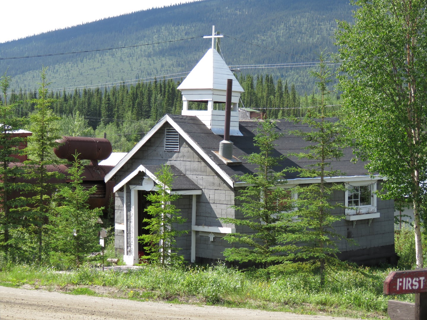
There were two churches in town, one Anglican, the other, Catholic. This is the Catholic one.


This building is a food cache which protected food supplies from animals and fire.


Fort Selkirk is also a traditional home for the Selkirk First Nation and they have a colourful, well-tended burial ground in the woods behind the Catholic Church.


 photo arrow.pngCONTINUE READING

Saturday 23 July 2016

Some of you may have heard of the Yukon Quest, the annual 1,000 mile dogsled race held annually between Whitehorse, Yukon and Fairbanks, Alaska. Did you know there is also a Yukon River Quest, 'the Race to the Midnight Sun', an annual paddling marathon on the Yukon River between Whitehorse and Dawson City, Yukon? At 715 km., it's the longest annual canoe race in the world. Although it's been run for the last eighteen years, we hadn't heard of it either. The race is open to solo and tandem canoes and kayaks, and voyageur canoes. This year's event, 2016, also had Stand Up Paddle (SUP) boards as an experimental class. By coincidence, the race was leaving Whitehorse on June 29, one day after we were leaving on our own transit of the same course. They were going to be racing 24/7 and we were doing a leisurely cruise, so, we expected them to breeze right past us on Lake Laberge which they did. We camped early and had a perfect vantage point to watch as they all came through. It was quite the sight!


The 1st place finisher (tandem kayak) finished in forty-four hours and 51 minutes. Wow! We took fourteen days on the same course. The participants were forced to do a seven hour layover in Carmacks and three hours at Coffee Creek, but, other than that, they were expected to paddle 24/7, unimaginable. 2nd place was a tandem canoe, 3rd another tandem kayak and 4th went to a voyageur canoe. Many people had doubts about the paddleboarders, but, nine of the eleven finished and will probably be in as a class for future years. One of the boards dumped in Five Finger Rapids, but, was able to recover and carry on. The racers may have enjoyed the challenge of the race, but, we also enjoyed being able to travel at our own pace, very slowly and savour the details along the way.
 photo arrow.pngCONTINUE READING

Saturday 16 July 2016

Before we were sailors, we were canoeists. As we are currently without a sailboat and missing travel by water we decided to get back to basics this summer and return to the canoe. Since reading Pierre Berton's book Drifting Home and exploring the Klondike on previous visits, the Yukon River has always been 'on the list' in the back of our minds. Now, we had the time and we were already in the place, so we decided to just do it. 'It' being a fourteen day, 706 km (439 mile) paddle down the Yukon River, starting in Whitehorse and ending in Dawson City. This is actually just a small section of the River which flows from its headwaters near Atlin BC all the way to the Bering Sea, 3,190 kilometres (1,980 miles) distant. The Whitehorse to Dawson City leg was the main route to the Klondike for the Gold Rush participants of 1898.


We've done a fair amount of wilderness canoeing in Ontario, but, that was a long time ago and frankly, the idea of wielding an 85 lb. canoe on our heads, along with all our gear, across forest portages just wasn't that appealing any more. That is the beauty of the Yukon River. There are NO portages, none! Even better, you don't really even have to paddle! The downstream current averages between 5-7 miles per hour and unless there are headwinds, it basically just requires steering and avoiding obstacles.

After the mad rush of provisioning and packing, it was exhilarating to push off into the current at Whitehorse. We couldn't believe how fast we were going and watched the shoreline speed by. Within twenty minutes, we spotted a pair of deer on the shore, all was looking good and we spent a comfortable first night at the entrance to Lake Laberge.

Lake Laberge was the first of just three 'obstacles' on the trip that we had misgivings about. The lake is thirty miles long, subject to headwinds and there would be little current to assist us through it. It was a hot, two-day slog of a paddle through and although very beautiful, we were glad to see the end of it. There weren't that many good places to camp, but, we managed to find a great spot both nights which afforded us long views up and down the length of the lake.


After leaving Lake Laberge, we entered into the section of the river known as the 'Thirty Mile'. This section is designated a national heritage river and part of the Klondike Gold Rush International Historical Park. It was narrow, sparkling clear, rocky and very lively with lots of riffles that caused us to ship water on occasion. We had to keep our wits about us to be sure we were in the right place at the right time. Our moving water skills were rusty and it wasn't a very relaxing ride. We were wondering if we had bitten off more than we could chew. Once we reached the end of this section and joined up with the Teslin River, it all changed. There were still many boils and eddies in the river, but,  it was wider, the water stayed flat and we didn't have to be quite so vigilant. We started to enjoy the scenery, like this patch of fireweed in one of the many burn areas we encountered.


Once we'd remastered our moving water pivot turns, we found that even with the fierce current we could ferry glide over to either bank for a quick tea break.


On the shore, we encountered details like these beautiful flowers found among the stones on a muddy beach.


The second obstacle that gave us pause was Five Finger Rapids. Historically, they were a major navigation obstacle and many people and ships have come to grief there. We checked the Rapids out by road beforehand and they didn't look too bad as long as you lined up properly, took the rightmost channel (on the far left in the picture below) which only had standing waves down the middle of it, braced well and didn't stop paddling. We shipped quite a lot of water going through, but, it was all over in a minute and although very wet, we were through and relieved it was done.


A few miles further downstream we encountered our third and final obstacle, the Rink Rapids, but, these were easily bypassed as long as you kept to the extreme right of the river. From here on there wasn't much else to worry about and the days passed easily one-by-one and they all seemed to blend together. The days were mostly warm and sunny, the first few hours each day were magical when it was cool, fresh and quiet and we glided along soundlessly. We saw fewer and fewer people as we went along. After Fort Selkirk, the half-way point, which I'll write more about later, we didn't see another soul for about five days, until one evening when the whump-whump-whump of a helicopter loudly announced itself. It landed on an impossibly tiny strip of marshy shore directly opposite our camp and dropped off three men and a bunch of equipment. They were picked up a few hours later and we were alone again.


The silence was again blissful. Although travelling the river today is very much a wilderness experience it wasn't like that during the years surrounding the Gold Rush. The whole length of it must have been a hive of industry. There were telegraph lines running along the shore (all the way from Vancouver to Dawson City). Along with the lines came telegraph stations, police posts, even post offices. There were stage crossings and roadhouses at regular intervals. Every bend in the river contained huge woodpiles. Men cut and stacked cordwood all winter to fuel the paddle steamers. It must have been noisy, with machinery running and steam whistles blasting at every 'meet' point in the river. Hard to imagine today, but, just step a few metres back from the shoreline into the trees and the evidence is all still there.


Steam sternwheelers operated regularly on the River up until the 1950's. The SS Klondike, on the hard now at Whitehorse was one. Hard to believe this huge ship: 64m (210 ft.) with a beam of 12.5m (41 ft.) and a draft of 0,6m empty (24 in.) - 1m loaded (39 in.) draft negotiated this river full of ever-changing sandbars and depths.  Not surprisingly, ships went aground regularly and they often had to employ winches and cables attached to shore to get them through the sticky bits.


I couldn't finish this post without mentioning the wildlife encountered, specifically moose. We saw lots, probably at least a dozen and each time it was a thrill. Often it was early morning, sometimes they were single and sometimes in pairs. We were transfixed by one that swam directly across the river, just ten metres from the bow of our canoe. 


It was a wonderful trip and we enjoyed it very much!
 photo arrow.pngCONTINUE READING

Tuesday 12 July 2016

We spent over a week on the Dempster Highway. We needed to head back down to Whitehorse to pick up our rented canoe for our next adventure, a two week trip down the Yukon River. We had some time to kill, so, we decided to take a detour onto 'The Silver Trail' highway leading to Mayo and Keno City, Yukon.

Much has been written about various Gold Rushes in the north, but, you don't hear much about the Silver Rush that occurred in the 1920's in the same general area. Mayo, on the Stewart River, was primarily a transportation centre where the ore was loaded up and transported by river. Keno City (named after a gambling game popular in mining camps), at the end of the road, was where the mining actually took place. At its peak, Keno City had around 5,000 residents. Its population fluctuated as the mining activity did. There is still active mining in the area, but, today, there are only around twenty residents left. We didn't expect it to be so interesting, but, it's quite a little tourism hotspot. There is a really excellent community and mining museum, a small community campground, a snack bar and along with many historic buildings, the newly-built Silver Moon Bunkhouse.


Some of the old buildings have been repurposed, like this old Anglican Church.


Others have been left to rot.


 In addition to the twenty human residents, there were a lot of rabbits!


Best of all, there was a road to the top of Keno Hill, above the tree line, where hikes were possible among all the old mining relics. We drove up on an incredibly clear morning and hiked a few km along the top of the ridge.


There was still snow up above the tree line.


Relics were everywhere.


We enjoyed seeing nesting birds.


We were also interested to see our first Hoary Marmot, the largest member of the squirrel family. These are slow-moving creatures who hibernate from September to May, they are only active four months a year. Most wildlife encounters are fleeting, this one was way too long. We couldn't budge him out from underneath the van. At one point, he climbed up underneath somewhere and we could no longer even see him. Starting the engine didn't work, slamming doors didn't work. Finally, we inched forward and out he came.


The highway back to Whitehorse had incredible wildflower displays along the roadside.


 photo arrow.pngCONTINUE READING

Sunday 3 July 2016

One of the primary reasons for returning to the North this summer, which will be the third summer in a row we have spent at least some time above the Arctic Circle, was to travel the Dempster Highway. We passed right by it last fall when winter overtook us and we had to turn south. The highway is currently the only road in Canada which reaches the Arctic Ocean, albeit only in the winter. In summer, the gravel road ends at Inuvik and then only an ice road is available in winter to reach Tuktoyaktuk, on the Arctic Ocean. All this will change next year (fall 2017) when the last piece of gravel road between Inuvik and Tuk will be opened. We didn't mind missing out on driving to Tuk because we had already spent time there last summer when we visited via sailboat.


It was a good time to travel, we had spectacular weather, only one day of rain. It takes about two days to drive the 736km from the start near Dawson City to Inuvik.


All the guidebooks had dire predictions about the road condition and warned motorists to be sure and carry a spare tire, even two. The reality was that the gravel road was much better than most we had traveled on in Alaska and elsewhere. It was dusty in places, there were some potholed areas, you had to travel slowly and watch carefully. Early on we saw a tractor trailer where a moment's inattention had caused him to catch the edge of the road and the whole rig was completely flipped over upside down in the ditch. It was a soft landing and it didn't look like there was any damage, although a crane would have to be brought from somewhere far away to right it. The road is built high with many layers of gravel to keep the supporting permafrost underneath well insulated. There are few guard rails or shoulders and the road is narrow, but, certainly easily driveable. We saw all types of vehicles on the road: a few bicycles, many motorcycles, small passenger cars and surprisingly, many European vehicles, mostly German, some Dutch, Belgian and French. Some were small RV type vehicles, but, there were some extreme vehicles as well. They looked like armoured tanks festooned with spare tires and more suitable for an epic, Mad Max-style off-road conquest rather than the excellent gravel road we were on. We asked one German couple how they got the vehicles here. Apparently, they ship them on cargo ships from Europe to Halifax and drive across Canada from there. Some of them traverse the entire American continent from top to bottom.


The highlight and really the only reason to drive the highway is the landscape and scenery. You pass through two Canadian territories, two mountain ranges, cross two large rivers (by ferry) and travel through five different 'ecozones'. First the Boreal Cordillera, then the Taiga Cordillera, the Taiga Plains, the Southern Arctic and finally the Northern Arctic. All are unique and beautiful in their own right. The area known as Beringia is an unglaciated landscape, thus, the mountain tops have not been scoured and there are many 'tors' and unique erosions on their tops. I'll let the pictures tell the story.

This picture is of 'Elephant Rock', one of the mountaintop rock formations.


Here is the Peel River cable ferry crossing, in the boreal forest.


Here is a view of Tombstone Mountain, in the Territorial Park of the same name.


We were disappointed not to see caribou, but, it wasn't the right time of year. Thousands of barrenland caribou cross the Dempster during their spring and fall migrations.Maybe next time?

In the boreal forest zone we saw bear, moose and ptarmigan. This black bear was on a mission to somewhere and marched down the middle of the road and right by us without even a glance our way.


This curious moose just stood and stared at us until we made the first move.


There were human interest stories as well. We visited the graves of 'The Lost Patrol' at the Anglican Church in Fort McPherson. The Dempster Highway was named for Sgt. WJD Dempster of the Northwest Mounted Police, who, in the winter of 1910-11, was sent to search for the 'Lost Patrol'.


 photo arrow.pngCONTINUE READING